|
|
Southeastern |
Map No. 1-E. Watershed Reserves are listed in the following Water Districts: Kamloops, Nicola, Princeton, Fairview, Grand Forks, Vernon, Revelstoke, Nelson, Kaslo, Golden, Fernie, Cranbrook. |
|
Nelson Water District - Upper
Slocan Valley: (3a) Rashdell and Angel Cks., |
|
|
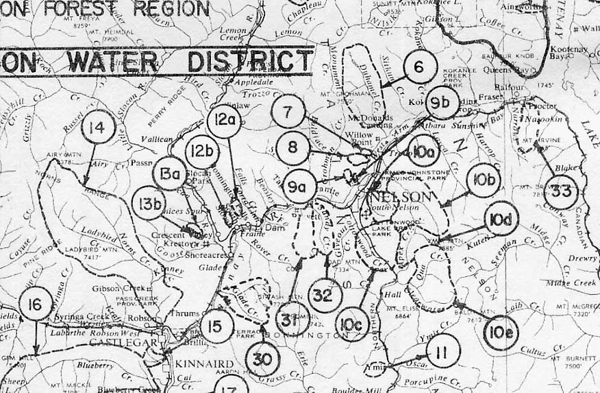
Nelson Water District - Nelson
City area: (6) Duhammel Ck., (7) South Blunt Ck., (8) Four Mile
Ck., (9a) Isaac (Van Wagner) Ck., (9b) Sutherland Ck., (10a) Anderson
and Fell Cks., (10b) Five Mile Ck., (10c) Cottonwood Ck., (10d)
Whitewater (Apex) Ck., (10e) Clearwater Ck., (11) Quartz Ck., (30)
Glade Ck., (31) Eagle Ck., (32) Sandy Ck., (33) Proctor Ck. Nelson
Water
District
- South Slocan and Castlegar City areas: (12a) Smoky
Ck., (12b) Watts Ck., (13a) Langill Ck., |
|
|
Nelson Water District -
Castlegar City and Trail City area: (15) Merry Ck., |
|
|
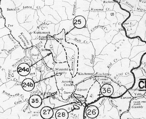
Nelson Water District - Creston City area: (24a) Duck Ck., (24b) Wyndell Ck., (25) Arrow Ck., (26) Sullivan Ck., (27) Camp Run Ck., (28) Lister Ck., (35) Glaser Ck., (36) Russell Ck. |
|
|
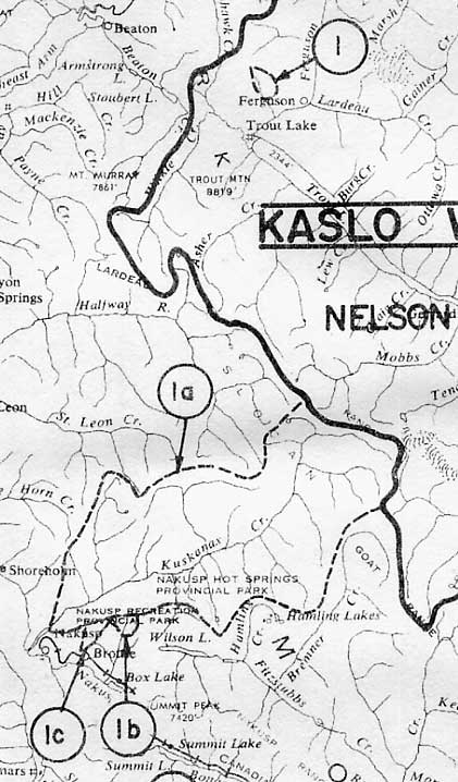
Nelson Water District - Town of Nakusp: (1a) Kuskanax Ck., (1b) Wensley (Halfway) Ck., (1c) Brouse Ck. Kaslo Water District - Trout Lake area: (1) Batys Ck. |
|
|
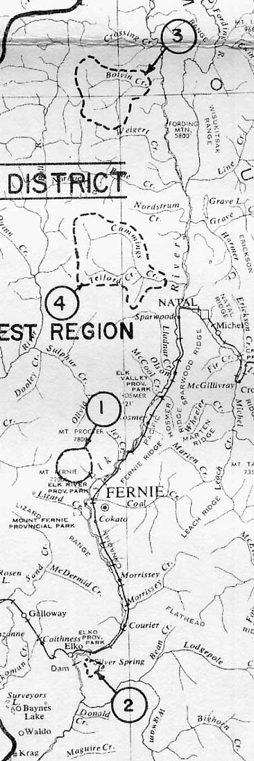
Fernie Water District - Town of
Fernie: (1) Fairy Ck., (2) Silver Spring Lake, |
|
|
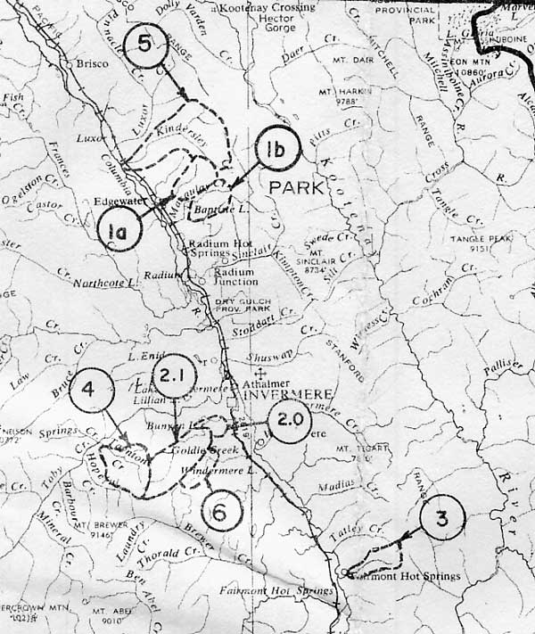
Golden Water District - Town of
Invermere: (1a) Sixty-Two Mile Ck., |
|
|
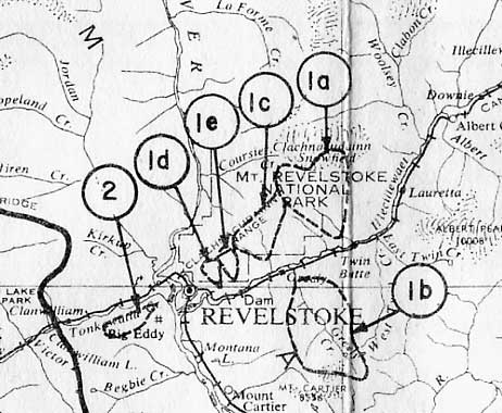
Revelstoke Water District - Revelstoke City: (1a) Clachnacudainn Ck., (1b) Greely Ck., (1c) Hamilton Ck., (1d) Bridge Ck., (1e) Napoleon Ck., (2) Dolan Ck. |
|
|
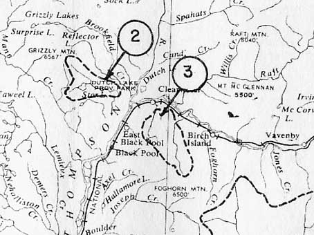
Kamloops Water District - Town of Clearwater: (2) Gill Ck., (3) Russell Ck. et al. |
|
|
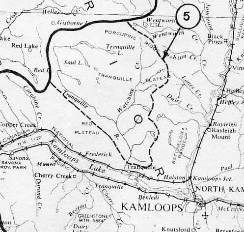
Kamloops Water District - Kamloops City: (5) Tranquille River. |
|
|
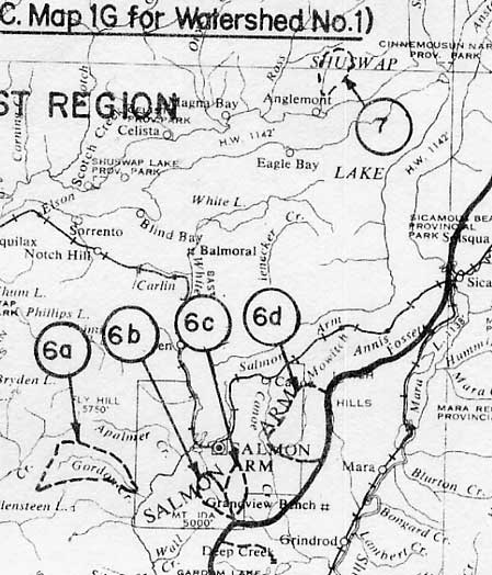
Kamloops Water District - Town of Salmon Arm: (6a) Gordon Ck., (6b) Hobson Ck., (6c) White Cliff Gulch, (6d) East Canoe Ck., (7) Hudson Ck. |
|
|
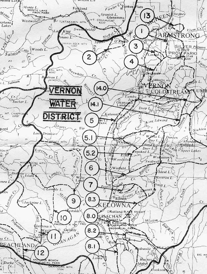
Vernon Water District - North Okanagan Valley: (1) Fortune Ck., (2) Irish (Coyote Ck., (3) Huntley Ck., (4) BX Ck., (5.0) Kalamalka Lake, (5.1) Oyama Ck., (5.2) Vernon Ck., (6) Kelowna Ck., (7) Whelan Ck., (8.0) Mission Ck., (8.1) Klo (Canyon) Ck., (8.2) Hydraulic Ck., (8.3) Mission Ck., (9) Lambly Ck., (10) Powers Ck., (11) Trepanier Ck., (12) Peachland Ck., (14.0) Duteau Ck., (14.1) Duteau Ck. |
|
|
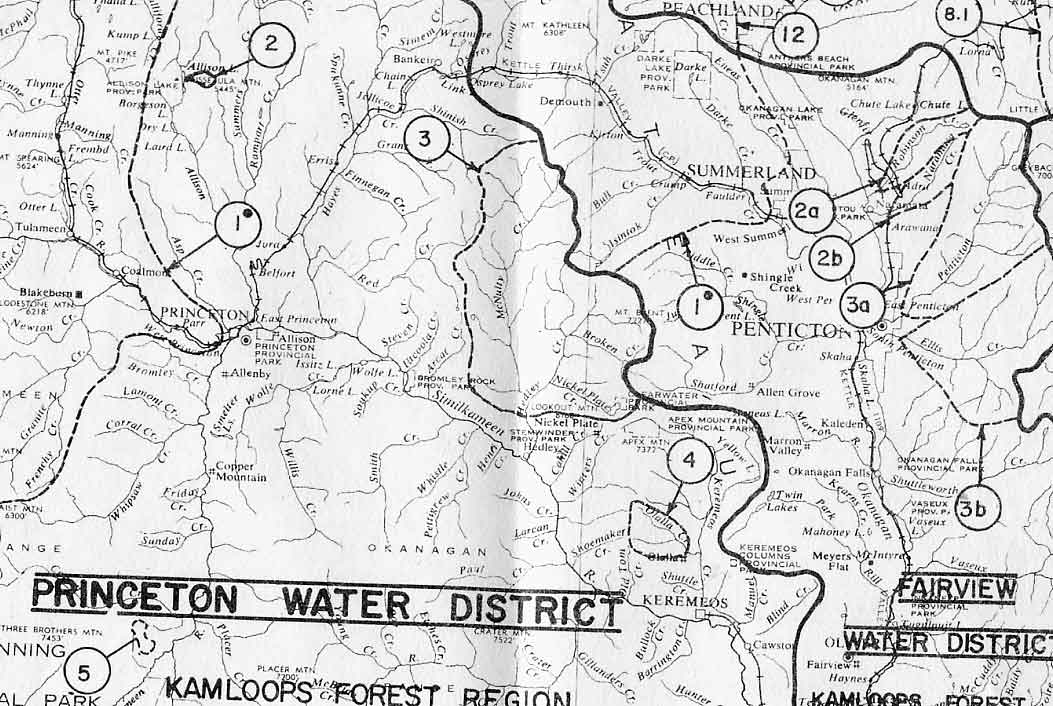
Fairview Water District - City of Penticton: (2a) Robinson Ck., (2b) Naramata Ck., (3a) Penticton Ck., (3b) Ellis Ck. |
|
|
Grand Forks Water District -
Town of Grand Forks area: (2a) Boundary Ck., |
|
|
Princeton Water District - Town of Princeton: (2) Anderson Ck., (3) Hedley Ck., (4) Olalla Ck., (5) Bell Ck. |
|
|
Southwestern |
Map No. 1-KLS. Watershed Reserves are listed in the following Water Districts: New Westminster, Vancouver, Victoria, Alberni, Nanaimo, Ashcroft, Cariboo. |
|
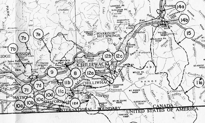
New Westminster Water District
- Upper Fraser Valley, Chilliwack City: |
|
|
New Westminster Water District - Town of Hope: (13) Yale Ck., (14a) Schkam Ck., (14b) Pringle and Campbell Cks., (15) Silverhope Ck. South Ashcroft Water District - Town of Lytton area: (5) Murray Ck., (6) Lytton Ck., (7) One & One Quarter Ck. |
|
|
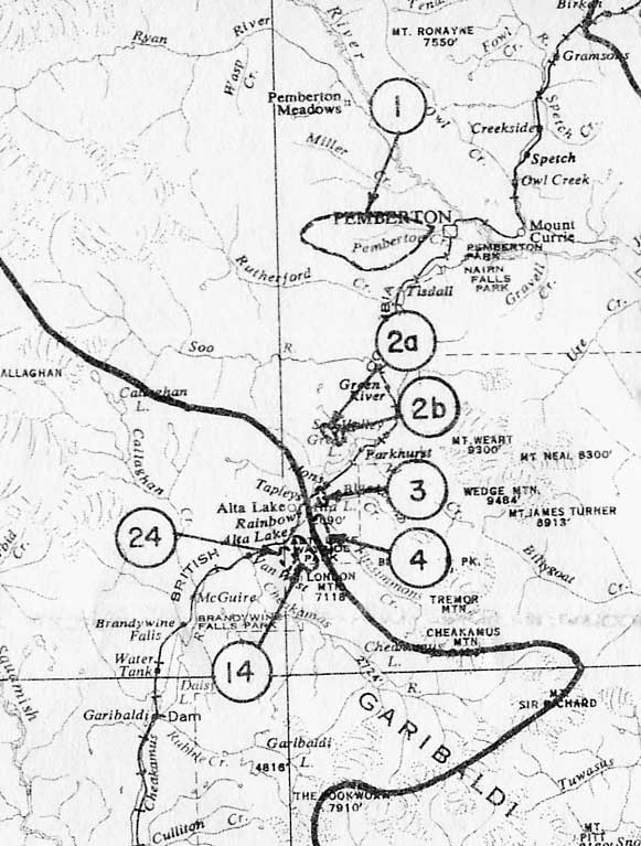
New Westminster Water District - Town of Whistler to Pemberton: (1) Pemberton Ck., (2a) Emerald Brook, (2b) Rideau Brook, (3) Crabapple Ck., (4) Archibald Ck. Vancouver Water District - Town of Whistler: (14) Whistler Ck., (24) Alpha Ck. |
|
|
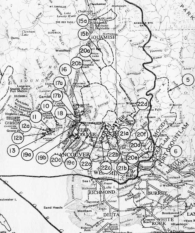
Vancouver Water District -
Greater Vancouver to Town of Squamish: |
|
|
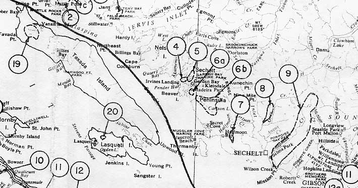
Vancouver Water District - Town of Sechelt, Sunshine Coast: (4) Hotel Lake, (5) Garden Bay Lake, (6a) Paq Lake, (6b) Haslam Ck., (7) Trout Lake and Milne Ck., (8) Irving Ck., (9) Chapman Ck. Nanaimo Water District - Texada and Lasqueti Islands: (19) Priest Lake, (20) Hadley Lake. |
|
|
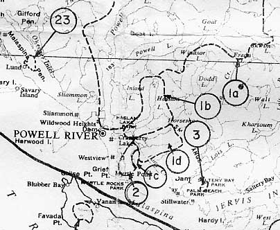
Vancouver Water District - Town of Powell River: (1b) Haslam Lake, (1c) Hamil and Powell Lake, (1d) Lang Ck., (2) Myrtle Ck., (3) Jefferd Ck., (23) Thulin Ck. |
|
|
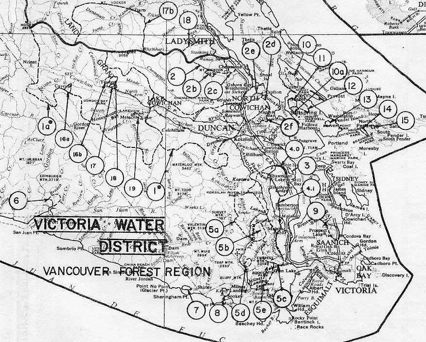
Victoria Water District - City of Victoria to Town of Ladysmith: (2) Banon Ck., (2b) Holyoak Lake, (2c) Chemainus Lake, (2d) Somenos Lake (2e) Richards (Crofton) Lake, (2f) Quamichan Lake, (3) Wace Ck., (4.0) Shawnigan Ck., (4.1) Shawnigan Lake, (5a) Sooke River, (5b) Council Ck., (5c) Goldstream and Waugh Cks., (5d) Mary Vine Ck., (5e) Ayum Ck., (6) Browns Ck., (7) Goudie Ck., (8) Kemp Lake, (9) Elk & Beaver Lakes, (10) St. Mary Lake, (11.0) Maxwell Ck., (11.1) Maxwell Lake, (12) Cusheon Lake, (13) Weston Lake, (14) Pender Lake & Shingle Ck., (15) Banon Ck., (19) Dole Brook. Nanaimo Water District - Town of Ladysmith: (17b) South Nanaimo River, (18) Stocking Lake. |
|
|
Nanaimo Water District - Nanaimo City to Qualicum Beach: (10) Nile Ck., (11) Little Qualicum River, (12) French Ck., (13) Englishman River, (14) Enos Lake, (15) Indian Reserve Ck., (16) Molecey Ck., (17a) Chase River. Alberni Water District: Town of Port Alberni: (3b) McFarland Ck., (3c) China Ck., (5) Gold Ck., (9) Rogers Ck. |
|
|
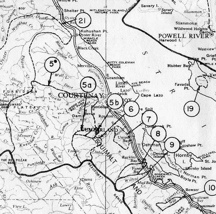
Nanaimo Water District - Town
of Courtenay: (5a) Cumberland Ck., (5b) Perserverance Ck., |
|
|
Alberni Water District - Town of Tofino area: (6a) Sharp Ck., (6b) Meares Ck., (7) Mercantile Ck. |
|
| Group No.26 |
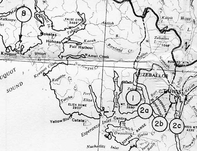
Alberni Water District - Town of Zeballos
to Kyoquot: (1a) Zeballos River, Zeb & Ballos Cks., (2a)
Extravagant Ck., (2b) Ubedam Ck., (2c) McKelvie Ck. |
|
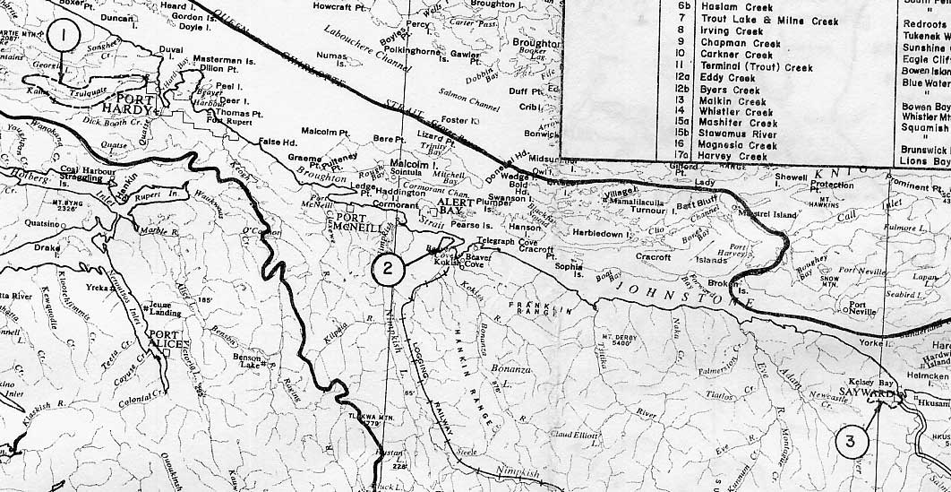
Nanaimo Water District - Town
of Port Hardy to Sayward: (1) Tsulquate River, |
|
|
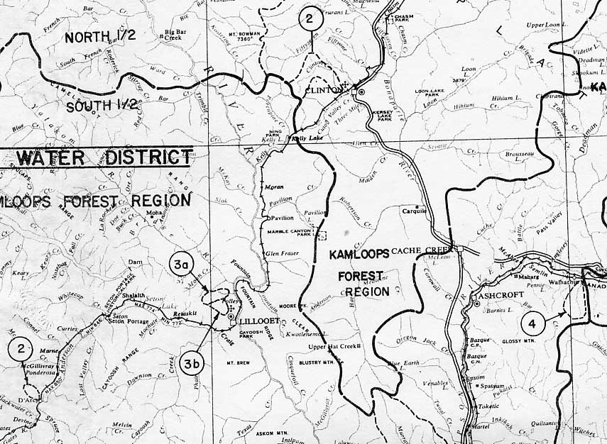
South Ashcroft Water District -
Town of Lillooet area to Ashcroft: (2) D'Arcy Ck., (3a) Dickey Ck.,
(3b) Town Creek, (4) Jimmies Ck. |
|
|
Northeastern British Columbia |
Map No. 1-G. Watershed Reserves are listed in the following Water Districts: Kamloops, Prince George, Peace River, Quesnel. |
|
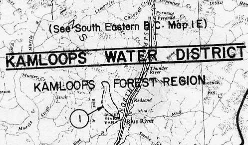
Kamloops Water District - Town of Blue River: (1) White River. |
|
|
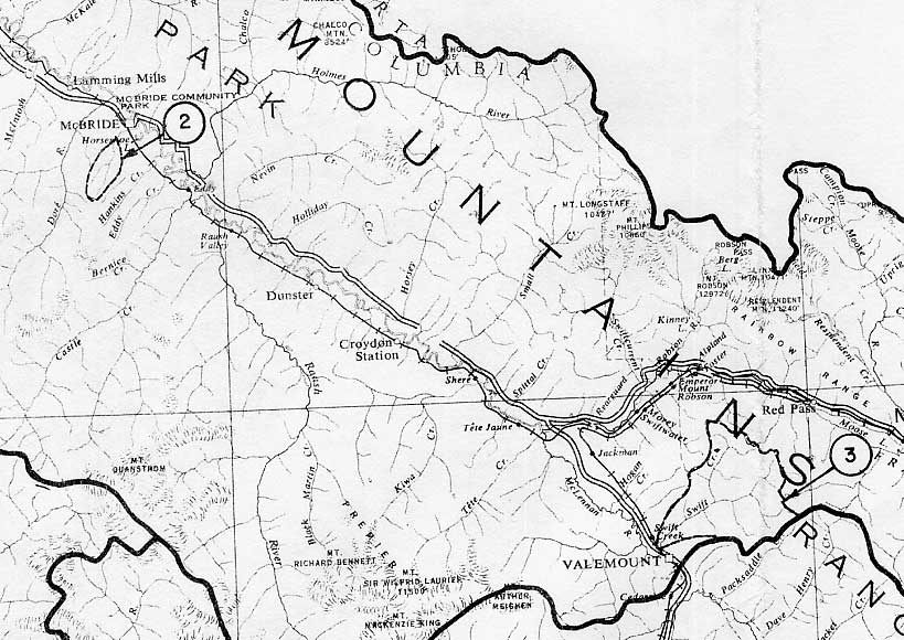
Prince George Water District - Town of Valemount, McBride: (2) Dominion Ck. (3) Swift Ck. |
|
|
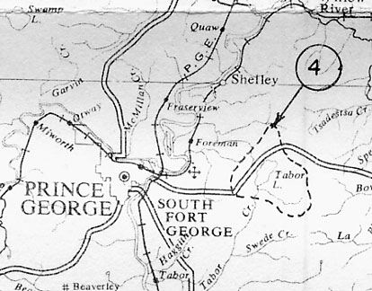
Prince George Water District - City of Prince George area: (4) Taber Lake. |
|
|
Quesnel Water District - Town of Wells: (2a) Red Gulch Ck. et al., (2b) Lowhee Ck. et al. |
|
|
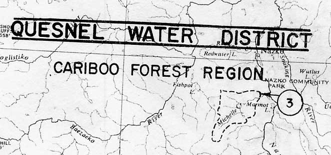
Quesnel Water District - Nazko Indian Reserve: (3) Michelle Ck. |
|
|
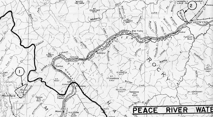
Prince George Water District - Town of MacKenzie: (1) Morfee Lakes. Peace River Water District - Town of Chetwynd: (2) Windram Ck. [Note Reserve No.(1) Charlie Lake is not indicated.] |
|
|
Northwestern |
Map No. 1-FLS. Watershed Reserves are listed in the following Water Districts: Hazelton, Prince Rupert, Vancouver. |
|
Hazelton Water District - Town of Hazelton: (1) Hospital Lake, (2a) Waterfall Ck., (2b) Station Ck., (3) Chicago Ck., (4) Ten Link Ck., (5) Two Mile Ck., (6) Sikadakh Ck. |
|
|
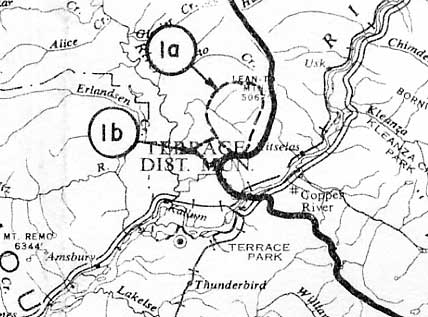
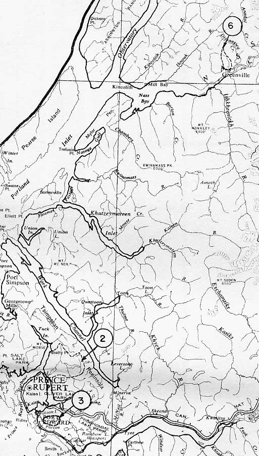
Prince Rupert Water District - Town of Terrace: (1a) & (1b) Deep Ck. & Spring Ck. |
|
|
Prince Rupert Water District -
City of Prince Rupert, Village of Greenville: |
|
|
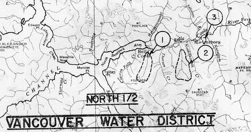
Vancouver Water District - Town of Bella Coola: (1) Tatskwan Ck. (2) Snootli Ck., (3) Gibbs Brook. |
|
|
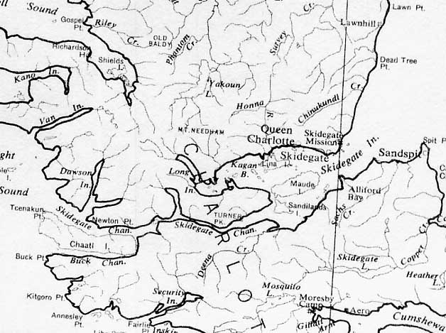
Prince Rupert Water District - Queen Charlotte City: (5) Gore Ck. [not indicated on government map] |